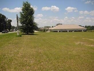
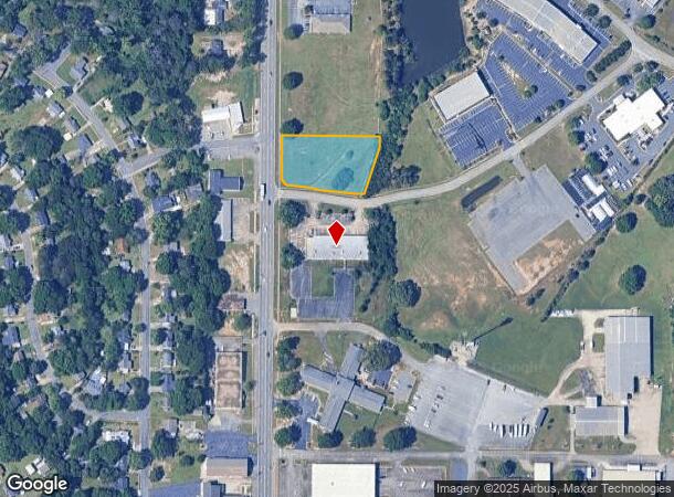
Property Record
101 N Prince St, Warner Robins, GA 31093
NEARBY LISTINGS FOR SALE OR LEASE
Property Detail
101 N Prince St
Warner Robins, GA
N Davis Dr 400 Ff
0W15AA044000
LOT 10 BLK C VILLAGE@TOWN CENTRE
Miscellaneous
Houston
AE
Georgia
13289C0200B
10
0
0.78 AC
2024
Perry/Warner Robins
020400
Other Market Areas
DEMOGRAPHICS near 101 N Prince St
1 Mile
3 Mile
5 Mile
2024 Total Population
8,111
43,244
80,930
2029 Population
9,047
47,524
88,777
Pop Growth 2024-2029
+ 11.54%
+ 9.90%
+ 9.70%
Average Age
36
37
38
2024 Total Households
3,054
17,169
32,232
HH Growth 2024-2029
+ 11.56%
+ 9.73%
+ 9.54%
Median Household Inc
$26,764
$50,032
$57,722
Avg Household Size
2.50
2.40
2.40
2024 Avg HH Vehicles
2.00
2.00
2.00
Median Home Value
$64,651
$102,460
$141,364
Median Year Built
1963
1973
1982
Nearby Places
Map Layers
Map Styles
 Street
 Aerial
- Restaurants
- Banks
- Shops
- Fitness
- Groceries
Nearby Properties
Address
Land Use
TOTAL SIZE
Lot Size
Zoning
Address
Land Use
TOTAL SIZE
Lot Size
Zoning
88,965 SF
18.72 AC
R2
Address
Land Use
TOTAL SIZE
Lot Size
Zoning
11,658 SF
30.23 AC
R2
Address
Land Use
TOTAL SIZE
Lot Size
Zoning
304,246 SF
23.11 AC
C2
Address
Land Use
TOTAL SIZE
Lot Size
Zoning
178,400 SF
49.03 AC
R2
Address
Land Use
TOTAL SIZE
Lot Size
Zoning
3,199 SF
41.42 AC
R4
Address
Land Use
TOTAL SIZE
Lot Size
Zoning
842,179 SF
101.75 AC
M2
Address
Land Use
TOTAL SIZE
Lot Size
Zoning
11,200 SF
7.60 AC
R4
Address
Land Use
TOTAL SIZE
Lot Size
Zoning
210,408 SF
47.18 AC
C2
Address
Land Use
TOTAL SIZE
Lot Size
Zoning
19,200 SF
14.70 AC
R4
Address
Land Use
TOTAL SIZE
Lot Size
Zoning
6,336 SF
27.16 AC
R4
Address
Land Use
TOTAL SIZE
Lot Size
Zoning
17,832 SF
13.60 AC
R4
Address
Land Use
TOTAL SIZE
Lot Size
Zoning
128,540 SF
32.26 AC
R2
Address
Land Use
TOTAL SIZE
Lot Size
Zoning
139,016 SF
24.71 AC
C2
Address
Land Use
TOTAL SIZE
Lot Size
Zoning
61,628 SF
45 AC
C2
Address
Land Use
TOTAL SIZE
Lot Size
Zoning
120,000 SF
19.03 AC
R3
Address
Land Use
TOTAL SIZE
Lot Size
Zoning
121,500 SF
10 AC
R2
Address
Land Use
TOTAL SIZE
Lot Size
Zoning
93,450 SF
11.16 AC
R2
Address
Land Use
TOTAL SIZE
Lot Size
Zoning
60,000 SF
8.95 AC
C3
Address
Land Use
TOTAL SIZE
Lot Size
Zoning
25,062 SF
R4
Address
Land Use
TOTAL SIZE
Lot Size
Zoning
25,062 SF
R4
Address
Land Use
TOTAL SIZE
Lot Size
Zoning
1,512 SF
309.01 AC
M2
Address
Land Use
TOTAL SIZE
Lot Size
Zoning
31,797 SF
9.45 AC
R2
Address
Land Use
TOTAL SIZE
Lot Size
Zoning
71,434 SF
10.58 AC
R2
Address
Land Use
TOTAL SIZE
Lot Size
Zoning
5,400 SF
16.21 AC
R4
Address
Land Use
TOTAL SIZE
Lot Size
Zoning
60,120 SF
13.97 AC
R2
Address
Land Use
TOTAL SIZE
Lot Size
Zoning
8,752 SF
11.71 AC
R4
Address
Land Use
TOTAL SIZE
Lot Size
Zoning
75,613 SF
11.51 AC
C1
Address
Land Use
TOTAL SIZE
Lot Size
Zoning
4,720 SF
12.53 AC
C2
Address
Land Use
TOTAL SIZE
Lot Size
Zoning
90,000 SF
9.20 AC
R2
Address
Land Use
TOTAL SIZE
Lot Size
Zoning
22,500 SF
9.80 AC
R2
The World's #1 Commercial Real Estate Marketplace
Connect with us
© 2025 CoStar Group
The information above has been obtained from sources believed reliable. While we do not doubt its accuracy we have not verified it and make no guarantee, warranty or representation about it. It is your responsibility to independently confirm its accuracy and completeness. Any projections, opinions, assumptions, or estimates used are for example only and do not represent the current or future performance of the property. The value of this transaction to you depends on tax and other factors which should be evaluated by your tax, financial, and legal advisors. You and your advisors should conduct a careful, independent investigation of the property to determine to your satisfaction the suitability of the property for your needs.